The Plan

Scroll to the top

Appendix to Clause 3-15: Trading Limits

  • Introduction

    In the 2019 Version the following amendments were made to this Appendix:

    • Trading areas II (Conditional trading areas), 3. Gulf of St. Lawrence and St. Lawrence River (Map No. 3): The map and the wording in the Appendix have been improved with the inclusion of map coordinates.
    • Trading areas II (Conditional trading areas), 4. St. Lawrence Seaway and the North American Great Lakes (Map No. 3): The map and the wording in the Appendix have been improved with the inclusion of map coordinates.
    • Trading areas II (Conditional trading areas), 5. East-Asian waters (Map No. 4): The map and the wording in the Appendix is amended by moving the great circle line to 10 nautical miles from land and by including map coordinates.
  • I. Excluded trading areas, cf. Clause 3-15 (Map No. 1)

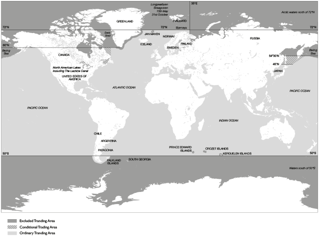
    1. The northern hemisphere


    1.1 European-Arctic waters

    The waters north of 72° north latitude, the area extending 100 nautical miles from the baseline of East Greenland and the area extending 50 nautical miles from the baseline of Jan Mayen. However, the limitation does not apply to voyages made directly to Longyearbyen and Sveagruven on Svalbard when the vessel passes 72° north latitude no earlier than 15 May, and departs from these places no later than 31 October. Vessels making such voyages shall pass no closer than 20 nautical miles and no further than 100 nautical miles west of Bjørnøya.

    1.2 Euro-Asian Arctic waters

    The waters north of the Euro-Asian continent east of 35° east longitude.

    1.3 East-Asian waters and the Bering Sea

    East-Asian waters and the Bering Sea north of 54° 30’ north latitude and waters that can only be accessed by crossing this line, including voyages to the Aleutian Islands.

    On voyages between places within the ordinary trading areas the vessel must in the Bering Sea pass west of Buldir Island or through the Amchitka, Amukta or Unimak Passes, on condition that it is equipped with up-to-date navigation equipment for these waters.

    1.4 North and North-Eastern American waters and the waters off West Greenland

    The waters north of 60° north latitude and waters which can only be accessed by crossing this line. The St. Lawrence Seaway and the North American Great Lakes during periods when vessel traffic in the canals is prohibited by the authorities.

    2. The southern hemisphere

    The waters south of 50° south latitude and the areas extending to 50 nautical miles from the baselines of Kerguelen, Crozet Islands and Prince Edward Islands. However, the limitation does not apply to voyages to Patagonia, Chile or the Falkland Islands, nor to passages through the waters south of 50° south latitude on voyages between places north of this latitude. Such voyages shall not be made more than 50 nautical miles south of the baselines of Chile, Patagonia and the Falkland Islands.

    Cefor wishes to extend its sincere thanks to Groupe Eyssautier for producing the maps

    Groupe Eyssautier logo


    Map No. 1

    Please click on the map to view a larger version.


  • II. Conditional trading areas, cf. Clause 3-15

    1. The Baltic Sea (Map No. 2)

    • The Gulf of Bothnia north of the line Umeå – Vasa,
    • The Gulf of Finland east of 25° 45' east longitude,
    • The waters east of the line Dagerort – Lyserort,
      during the period 15 December to 15 May, both days included.


    2. Labrador (Map No. 3)

    The waters from Cape St. Charles to 60° north latitude, all year.

    3. Gulf of St. Lawrence and St. Lawrence River (Map No. 3)

    • The waters within lines drawn between Port Hastings Swing Bridge W (45°38.8’N 061°24.8’W) - Port Hastings Swing Bridge E (45°38.9’N 061°24.8’W) (Strait of Canso), Cape North (47°01.7’N 060°23.5’W) and Cape Ray (47°37.3’N 059°18.2’W) (Cabot Strait), Cape Bauld (51°38.4’N 055°25.6’W) and Cape St. Charles (52°13.1’N 055°37.2’W) (Strait of Belle Isle) and Baie Comeau (49°13.5’N 068°09.0’W ) and Matane (48°50.8’N 067°34.5’W) (St. Lawrence River) during the period 21 December - 4 April.
    • The waters from the line Baie-Comeau (49°13.5’N 068°09.0’W)- Matane (48°50.8’N 067°34.5’W) up to and including the port of Montreal at Victoria bridge (45°29.2’N 073°32.2’W to 45°29.4’N 073°31’W) during the period 6 December - 4 April.


    4. St. Lawrence Seaway and the North American Great Lakes (Map No. 3)

    The area above Victoria bridge, Montreal from the opening of the canals until 30 November.

    5. East-Asian waters (Map No. 4)

    East-Asian waters north of 46° north latitude and south of 54° 30' north latitude to the great circle line between N 46°, E 151° and N 54°30’, E 170° during the period from 1 November to 1 June, both days included.

    Map No. 2

    Please click on the map to view a larger version.

    Map No.2

    Map No. 3 (see sub-maps 3a - 3e)

     Please click on the map to view a larger version.

    Map No.3

    Map No. 3a

    Map No. 3a

    Map No. 3b

    Map No. 3b

    Map No. 3c

    Map No. 3c

    Map No. 3d

    Map No. 3d

    Map No. 3e

    Map No.3e

    Map No. 4

    Map No.4